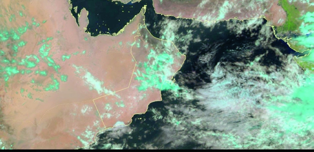


MUSCAT: Weather indicators suggest that Oman will be affected by a low-pressure trough starting on Sunday, August 17, according to the National Multi-Hazard Early Warning Centre, Civil Aviation Authority.
The latest weather maps and forecasts indicate that this system will persist for several days, bringing cloud cover and scattered rainfall to Al Sharqiyah South Governorate, Al Wusta Governorate, parts of the Al Hajar Mountains, and surrounding areas. Specialists at the Early Warning Centre are closely monitoring developments.
On Saturday, most governorates experienced a continued flow of clouds with scattered rainfall. In Dhofar Governorate, coastal areas saw partly cloudy to cloudy skies with intermittent drizzle. The forecast predicts medium to high cloud advection and isolated rain over other regions, along with convective cloud formation and occasional thundershowers over the Al Hajar Mountains and nearby areas.
Late-night and early-morning fog patches are expected along the coastal areas of the Arabian Sea and the Sea of Oman, which may reduce visibility. Downdraft winds could also stir up dust over deserts and the open regions.
The Directorate General of Meteorology has cautioned the public to remain alert, as wadis could flow during these weather conditions. Rainy cumulus clouds with occasional strong winds were already observed over parts of the Al Hajar Mountains in Al Dhahirah Governorate, Al Dakhiliyah Governorate, and Al Sharqiyah North Governorate.
Residents are advised to follow updates and take necessary precautions as the low-pressure trough affects the Sultanate of Oman over the coming days.
Oman Observer is now on the WhatsApp channel. Click here