
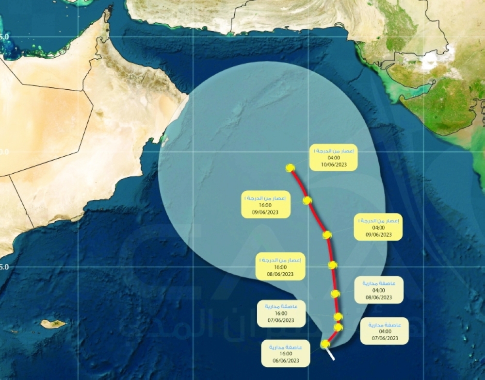


A depression formed in the southeast Arabian Sea on Tuesday, about 1,160 km from the coast of the Sultanate of Oman, quickly developed into a tropical storm named Biparjoy. The cyclonic storm will intensify into a severe cyclonic storm by Thursday morning and very severe cyclonic storm by Friday evening in areas adjoining Arabian Sea. But it may not have an impact on the Sultanate of Oman, experts said.
A weather forecaster from Oman Meteorology said, “Direction is still ambiguous and has many probabilities. Some models see it moving towards Gujarat, India, while others point towards Masirah Island, Oman. The tracks are many but it will be critical after three to five days. Now it is a tropical storm and the next 24 hours is crucial for us to come to the right understanding of the system.”
The name Biparjoy was given by Bangladesh and means 'calamity' or 'disaster'. As per IMD website, the name was adopted by World Meteorological Organisation (WMO) countries in 2020.
The development of this system has been fairly fast as when Observer spoke to Bushra al Saadi, Meteorology Specialist at National Multi Hazard Early Warning Centre, said, “The tropical system is expected to move north west of the Arabian Sea with no direct impact over Oman in the next five days. Maybe after five days the direction might change. There would be direct or indirect effects over the coast of Oman until then everything is stable in terms of weather conditions.”
Earlier in the week, one of the weather forecasters had explained that one of the signs that there is a status change in the tropical system could be seen in the wind.
Every category is different from the low pressure to depression, deep depression to tropical storm and tropical cyclone. The wind speed around the centre of the tropical storm is 40 knots according to Al Saadi.
“For now the movement shows towards north to northwest most likely to the Indian coast and Pakistani coast, but maybe in the coming hours and days there could be changes,” noted Al Saadi.
She explained that there is a low chance of Oman’s coast getting affected. The wind will not cool down the temperature as summer is approaching, but can cause downdraft wind resulting in dust rising and movement of unstable objects.
Along the Oman Sea coast, winds will be northeasterly light to moderate during the day time becoming southwesterly light at night, while along the rest of the governorates it will be southerly to southwesterly light to moderate occasionally fresh along the coastal areas of the Arabian Sea and deserts areas.
“An exceptionally warm Arabian Sea, a weak monsoon onset, and favourable Madden Julian Oscillation (MJO) conditions are favouring this cyclone,” Roxy Mathew Koll, a climate scientist at the Indian Institute of Tropical Meteorology, wrote on Twitter.
The sea surface temperatures are 30-32 degrees Celsius. “This is above the climatological mean. This is clearly the climate change link, as Arabian Sea warming is favouring more intense cyclones,” Koll tweeted. High sea surface temperatures favour the formation of cyclones.
Further, MJO, an eastward-moving disturbance of clouds, rainfall, winds and pressure that moves in the tropics, is active in the Indian Ocean, making conditions conducive for the formation of a cyclone, according to Koll.
MJO is different from El Nino-Southern Oscillation (ENSO), a recurring climate pattern involving changes in the temperature of waters in the central and eastern tropical Pacific Ocean.
@lakshmioman
Oman Observer is now on the WhatsApp channel. Click here