

It’s the Western Hemisphere’s original superhighway: Long before Route 66 or the Oregon Trail or even the Erie Canal — for that matter, before Henry Hudson ever sailed into New York Harbor — French ships, trailing the wake of Indigenous peoples such as the Mi’kmaq and the Innu, were already navigating the St. Lawrence River to explore, settle and exploit the New World. To this day, the St. Lawrence moves more than 150 million tons of cargo a year. But it can also move people, in unexpected ways. Follow alongside, and it will take you through other countries. And realms. And even back in time.
The fleuve Saint-Laurent — a fleuve is a river that empties into the sea; others are merely rivières — flows northward from Lake Ontario for some 800 miles, but a good place to start shadowing it would be about one-third of the way downstream, at the Plains of Abraham, in Québec City, where, in 1759, the British effectively secured their hegemony over the French in this part of the world for the next two centuries. Stand up there, on this elevated battleground, and gaze out — over the rooftops of the city that Samuel de Champlain founded 12 years before the Mayflower left England — at the fleuve, spreading out like a bay, and, to your right, two bridges that span it.
The last two.
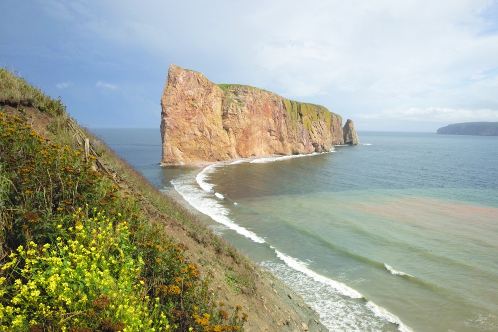
You don’t have to go across; you could just remain on this side, where Champlain planted roots, and visit waterfalls, ski resorts, artsy towns. But that other side — it’s mysterious. Somewhere out there — around 500 miles of two-lane macadam away — is Rocher Percé (pierced rock), a striking offshore monolith, one of Canada’s great icons, and next door, Île Bonaventure, where cliffs rising hundreds of feet from the water teem with birds rarely spotted south of the border. Both merit the drive; but to do it straight in one day — rather than, as I did, over the course of several — would be like going to an épicerie, buying a Coffee Crisp bar (that cherished Canadian confection), framing the wrapper and throwing the candy away.
Leaving Québec City
Cross over into the city of Lévis and pick up Quebec 132, the road that will take you all the way around the Gaspé Peninsula. At first, suburban sprawl obscures the river; then, suddenly, you’re in the middle of lush farmland with open driver’s-side views of the fleuve. This region is known as Chaudière-Appalaches, as in, the Appalachian Mountains. They’re up here, too, lurking somewhere off to your right.
You’ll pass many cyclists, their bicycles strapped with bulging saddlebags; the road here runs flat and straight. The coast, though, does not, so while 132 goes right through some towns, others nestle off to its left. Detouring through one every five or 10 minutes is like unwrapping Christmas presents.
Although they all look like charming mashups of New England and old France, each is distinct from its neighbors. In Saint-Vallier, for instance, I stumbled upon an otherwise nondescript home, its front lawn festooned with more than a dozen elaborate scale models: houses, shops, a gazebo, a church. A neighbor who noticed me gawking walked over to explain, “They’re all buildings in town. The fellow who lives here used to make one a year. He’s 85 now and can’t do it anymore, but he still puts them out every June and takes them in come winter.”
The town of L’Islet has a splendid stone church with gleaming twin spires. Although the parking lot was empty when I passed through, a side door was unlocked; inside, a woman encouraged me to explore its capacious interior, warmer and sunnier than any ornate église I’d ever seen. “This is a patrimoniale church,” she beamed, meaning it’s landmarked, a designation that carries even more prestige here than it does in the States. “It was built in 1768, after the town outgrew two earlier ones.”
Follow the steeples. Churches here stand at the center of town; around them, you’ll often find warm cafes, humble museums, public artwork, homemade chapels, placid riverfronts, little houses painted in bright colors, and sometimes — full disclosure — a potent whiff of cow manure. Fertile land, this.
Entering Bas-Saint-Laurent
At Sainte-Anne-de-la-Pocatière, past a sign welcoming you to the next region, Bas- (or lower) Saint-Laurent, a roadside shrine lists the town’s pioneers, going back to 1715. Others nearby were settled even earlier, like Kamouraska.
There are a few things that will stop you in Kamouraska. There’s that founding date, of course (1674); but there’s also its name — I’m told it’s Algonquin for “the place where rushes grow at the edge of the water” — which may well be the first thing you’ve seen on this whole drive to remind you that other people were living in these parts before the French sailed in.
But what will really stop you in Kamouraska is all the foot traffic, right along 132: people exploring historical sites, yes, but also plenty of boutiques, galleries, eateries. I asked the gentleman at the visitors bureau what drew people there in the first place, figuring the businesses had followed the tourists. “We’re known for having the second-most-beautiful sunsets in the world,” he said. Having heard tell of other Saint-Laurent towns with spectacular sunsets, I asked him where No. 1 was. “Hawaii,” he replied.
Into Gaspésie
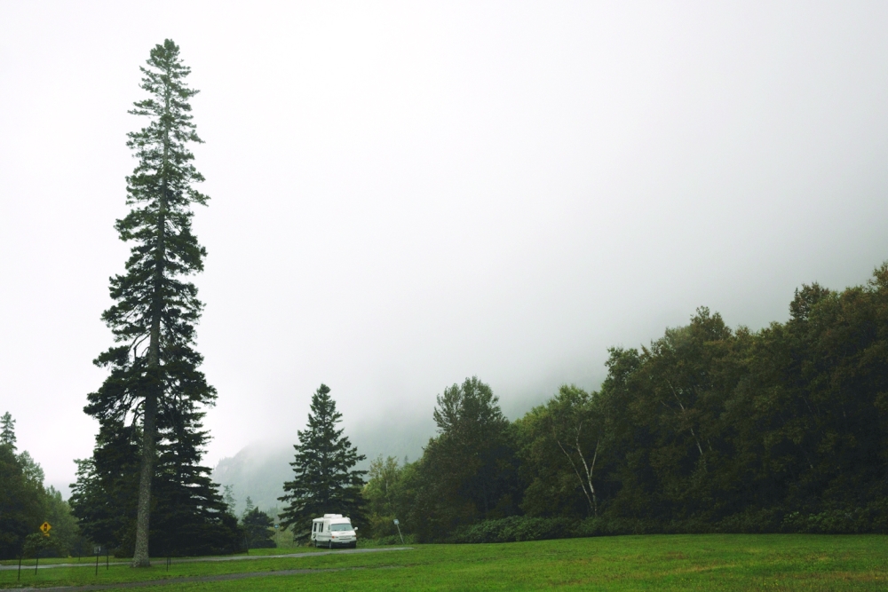
At some point, it will occur to you that you can no longer see the opposite bank, and you’ll come to understand why folks here refer to the river as la mer, the sea. At Sainte-Flavie, you enter the region of Gaspésie. The towns get noticeably smaller and even farther apart, the Christmas presents more surprising, including working phone booths and mechanical gas pumps.
More than 200 years have passed since Métis-sur-Mer was founded by a Scottish seigneur, but it’s still somewhat Anglophone. (It was “Métis Beach” until 2002.) It still has a Presbyterian church, too; in its graveyard, scattered among the marble and limestone, you’ll find a few wooden markers, long since weathered to illegibility. At Baie-des-Sables, while you stroll yet another waterside promenade sprinkled with comfortable chairs, it may occur to you that there is in these towns a tremendous sense of civic pride; almost everything in them is tidy, well kept (even abandoned houses have mowed lawns) and, by the shore, inviting.
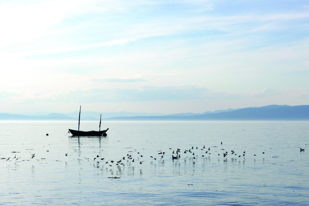
Past Matane, the coast starts to bulge and buckle with approaching mountains. Towns bear-hug the water, sometimes even spilling out over it, like Sainte-Anne-des-Monts, where I came upon a large quay, its surface covered with vehicles, its edges with anglers. These settlements were built on fishing, but people here apparently love it so much, they do it in their spare time, too.
At the Peninsula’s Ceiling
Soon thereafter, you will have crested the peninsula, your car’s compass having gradually spun from NNE to just E. It’s here, at the ceiling of Gaspésie, that the Appalachians finally end, and not with a whimper. They crash right into the water, forcing the road to accommodate them by rising and falling and contorting such that you may feel it’s trying to shake you off its back.
But then: those views. Here analogy fails me; I know of none like them. If you’re the type of person who stares at far-flung places on maps and envisions what they must be like, this one will exceed your imagination. At one point, for instance, a sharp bend in the mountainside road suddenly reveals a vista of more mountains alternating like the teeth of an opening zipper; before them, the village of Mont-Saint-Pierre clings to the slender rim of a half-moon cove. Stand on its dark-gray-speckled-with-white beach, looking forward and back, and you’ll wonder how any thoroughfare — much less the modest one beside you — can possibly make it around the promontories jutting into the sea.
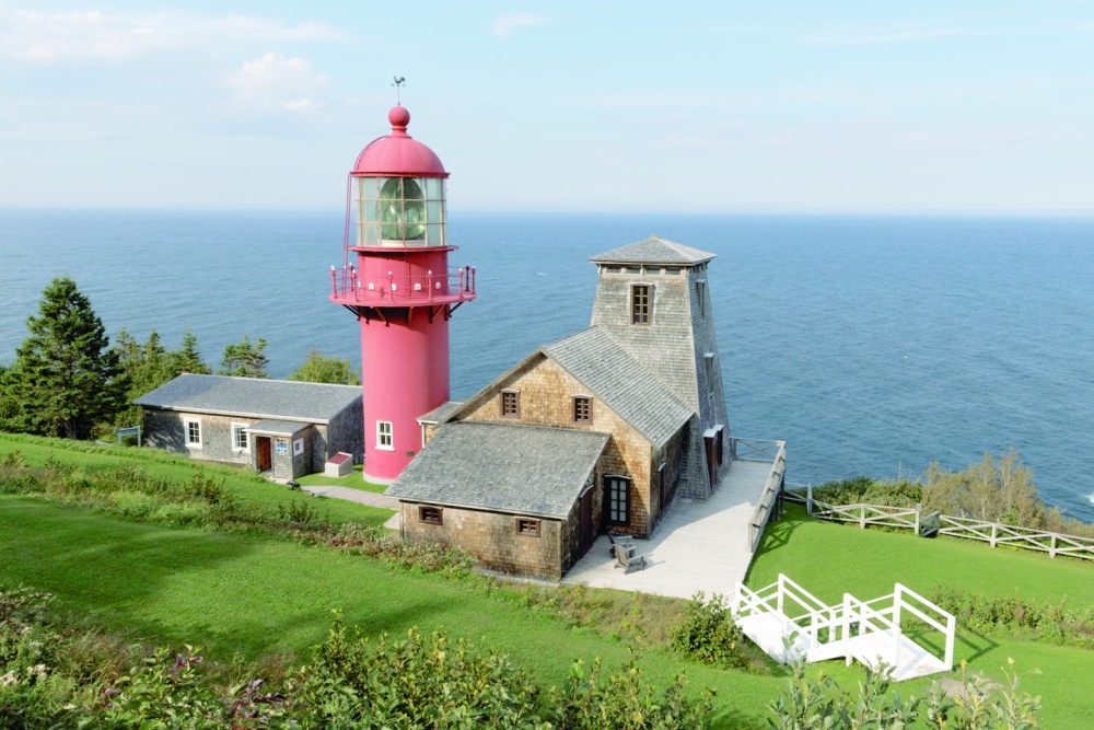
Past each, other mountains inch back from the shore just enough to accommodate settlements, some only one house deep; a few are simply a handful of small dwellings huddling together against blue infinity. Others are a bit larger, like Madeleine-Centre, where the lighthouse — you’ll have passed many by now: wooden, stone, brick; white, red, white and red — has a small museum that illuminates the history of the area, the life of a lighthouse keeper, and the indispensability of such structures, quaint artifacts though they seem now: In just two decades, from 1856 to 1876, the St. Lawrence swallowed at least 674 ships.
At the eastern tip of the peninsula, Forillon National Park leaps out into the Gulf of St. Lawrence. Nearly 100 square miles of conifers, beaches and capes, it was created in 1970, though not without tears: As kiosks at an anse, or cove, there explain, a great many families, some of whom had been there for centuries, were displaced in the process; their memories and lamentations grace other kiosks. (“We had lots of fun at Christmas.” “Families always got together for meals; it was a tradition.” “I know it’s been over 40 years but it still hurts. We’ll never forget.”) Some of their empty houses remain, as does William Hyman’s store, which provisioned generations of cod fishermen.
That cove is called L’Anse-aux-Amérindians (thankfully renamed from L’Anse-aux-Sauvages) to commemorate earlier generations of displaced residents. A trail that starts nearby leads to this eastern tip’s eastern tip, Land’s End. Its French name, Le Bout du Monde, seems more apt — the End of the World — and yet, somehow, inadequate; ride a whale-watching boat around the Gulf, and you’ll behold a land-and-seascape — indigo water waging an ancient war on ocher cliffs, more than you can count — best described as otherworldly.
Hunkering Down in Gaspé
Heading on, you’ll pass Fort Péninsule, a preserved coastal defense dating to World War II, when the Nazis sank some two dozen Allied ships in the St. Lawrence, before you come into the city of Gaspé, population 15,000. The town of Percé — where the sights include not only Rocher Percé and Île Bonaventure but also more souvenir and tchotchke stores than I care to recollect, not to mention the first paid parking lots I’d encountered in 500 miles — is still about 45 minutes away; but again, don’t rush. Gaspé, one of the great natural harbors on the Atlantic — with its nearby beaches and surprisingly warm water, enticing restaurants and shops, fine regional museum and snug main street, Rue de la Reine, where the lampposts and parking meter poles are outfitted with rainbow-striped knitted cozies — is as good a place as any I can think of to hunker down for a bit.
Jacques Cartier would agree. A tall stone cross on Gaspé’s waterfront marks the spot where the explorer planted a more modest wooden one in 1534, when he stopped by seeking shelter from a storm and decided to do some trading with the locals — and, while he was there, invoke the papal Doctrine of Discovery (the one that decreed Christian nations like France could just assert ownership of territory already occupied by non-Christian Indigenous peoples) to claim the land for King François.
What he claied — about 35 years before Champlain was born — is what we now call Canada. Although Gaspé also sometimes refers to itself as the End of the World, it was, in fact, the beginning of a whole new one — and well worth traversing several to see. — NYT
Oman Observer is now on the WhatsApp channel. Click here