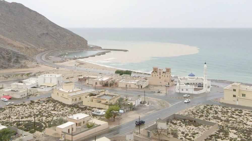


The Sultanate of Oman ushered in the New Year 2022 with steady rains, heavy at times, with thunderstorms and strong wind.
Heavy rains are expected on Sunday and Monday. Precipitation will be mostly in Musandam, North Al Batinah and Al Buraimi. The rain will likely cover most parts of the country on Tuesday and Wednesday again. Precipitation is expected to be 20 to 50mm.
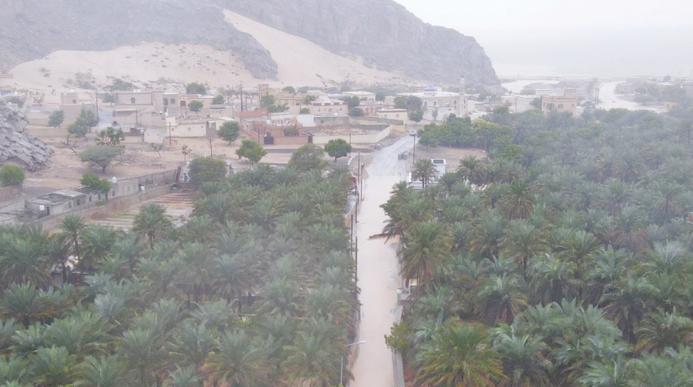
Since Friday there have reports from Nakhl and Samayil about flowing of wadis. Al Khod and the Seeb Dam received large amounts of water due to continuous rainfall, according to the weather forecaster at the Met Office.
“While the next two days may have lesser rain in this part, Al Batinah, Al Buraimi and Musandam might receive heavy rains on Sunday and the day after tomorrow and we are expecting the wadis to flow again and low areas can be flooded as the soil has already been affected by the four-day trough, which is also expected to continue for another four days. With 20mm of rainfall, the wadis can easily overflow,” said Jaifar bin Hamed al Busaidy, the weather forecaster at the National Multi Hazard Early Warning Centre.
While many wilayats in the northern part of the country received thundershowers due to trough of low pressure, the next two days, southeasterly winds (moderate to active) will continue to blow over most of the governorates, with high sea waves on the coasts of Musandam and the Sea of Oman with the possibility of dust and dust rise in desert areas.
The desert areas of the governorates of Dhofar, Al Wusta, Al Dakhiliyah, Al Dhahirah and Al Buraimi are likely to witness southeasterly winds of 10-20 knots (20-40 km/h) with a decrease in horizontal visibility due to the rising of dust.
“As this trough is strong, we are expecting fresh wind in the desert area also reducing visibility in Dhofar, Al Wusta, Al Dhahirah and Al Buraimi in addition to dust rising as there has not been much rain in these areas.
“We are expecting this impact, especially on the Adam to Thamrait road and the other desert areas where companies are located. The wind speed is expected to be 20 to 40 km,” he pointed out, adding that companies located in these spots should be cautious.
Saturday came with weather alert stating heavy thundershowers are expected over the governorates of Musandam, Al Buraimi, Al Dakhiliyah and South Al Batinah.
The thundershowers were accompanied by fresh downdraft winds, hail precipitation and flow of wadis, including flash wadis. The highest amount of rain recorded in some of the monitoring stations of the Civil Aviation Authority during the past 24 hours in Bidbid was 56.2mm and Nakhl 34.6mm.
According to the latest weather analysis in the National Multi Hazard Early Warning Centre, moderate sea condition along most of the country’s coasts with a maximum wave height of 2.0 metres becoming rough during thunderstorms along the coast of Musandam Governorate and other coastal areas of the country with a maximum wave height of 3 metres.
The continued flow of clouds over the northern atmosphere of the country led to rain of varying intensity, sometimes thunder, over the governorates of Muscat, North Al Batinah, South Al Batinah, Al Dakhiliyah, Al Buraimi, Al Dhahirah and Musandam, as well as the governorates of North and South Al Sharqiyah.
Continuing activity and flow of convective clouds over the governorates of Musandam, North Al Batinah and Al Buraimi, which led to rains, have resulted in the flow of wadis.
Oman Observer is now on the WhatsApp channel. Click here