


The tropical depression expected to cross Dhofar in the next eight to 10 hours is also having an impact on Al Hajr Mountains.
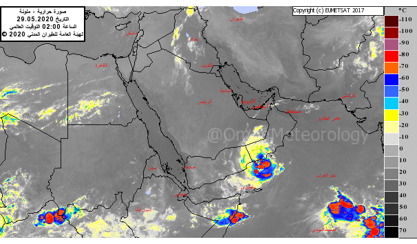
The Latest weather charts and the analysis of the National Multi Hazards Early Warning Center indicate that the tropical depression is located south of coastal areas of Dhofar governorate at longitude 54.5 degrees E and latitude 16.5 degrees N with estimated surface speed around 17 and 25 knots (30 to 45 km per hour).
The system is expected to intensify further as it crosses the coast in the coming hours.
According to the weather forecaster at the National Multi Hazards Early Warning Center, the system already has brought in rains and so far Taqah has seen the highest amount of rainfall in the last two days – 168 mm. In the last 24 hours Taqah received 67.2 mm, Qairoon Hairiti – 45.6 mm, Salalah – 43.6 mm, Mirbat – 41.2 mm, Dalkhut – 39 mm and Sadah 25.6 mm.
In the next two days 100-200 mm of rainfall is expected in Dhofar.
“The weather system will continue till Sunday with heavy rains and on Monday it is expected to weaken and slow down with some isolated rains,” explained the weather forecaster.
An interesting element of the low pressure that has developed over the Arabian Sea is that it is beginning to have an impact on Al Hajr Mountains which already has its local clouds.
“The impact of the low pressure can be experienced in Al Hajr Mountains and the surrounding areas and this is due to the fact that low pressure absorbs humidity from everywhere so there will be some low clouds in the coastal areas as the wind is moving from the sea to the land. During midday the local clouds will have advantage to develop further. We can see a lot of cloud development and the mountains can expect heavy rains accompanied by fresh wind and hail. This will continue in the next two days,” said the weather expert when asked how could Al Hajr having an impact from a system that is occurring in the South.
Explaining further the weather expert said, “Al Hajr has two sources of humidity from the Sea of Oman and the Arabian Sea. From Duqm to Al Ashqara and Jaalan the wind direction is southeast so it will move forward to Al Hajar Mountains and collide with the wind coming from the Sea of Oman. Al Hajr Mountains have a combination of elements – the mountains and the place is ideal for humidity to rise resulting in convective clouds.”
Meanwhile, the Public Authority for Civil Aviation advised the public to take precautions and stay away from low lying areas, as well as avoid crossing wadis and venturing into the sea.
Sea condition is reported to be rough along the coast of Dhofar Governorate with a wave height of 4 – 5 meters and Al Wusta governorate with a wave height of 3 meters.
The low pressure had formed over the southwest Arabian Sea near Socotra Islands and over the hours has concentrated into a Depression.
Another low-pressure area is likely to form over the southeast Arabian Sea towards the end of May 2020, according to the weather forecast from Oman Met Office.
Oman Observer is now on the WhatsApp channel. Click here